|
|
| Harmonized World Soil Database v 1.2 | |||
|
NEW UPDATE!! 7 March, 2012 - Version 1.21 is a minor release that fixes a few issues in Version 1.20. Please uninstall the previous version before installing this new version. (For a full description of HWSD updates through time, see the 'Download Data Only' link in the menu.) 2 February, 2012 - Version 1.2 now includes SOTER/SOTWIS data for Tunisia and additional Bulk Density information. (For a full description of HWSD updates through time, see the 'Download Data Only' link in the menu.). Please uninstall the previous version before installing this new version. ABOUT HWSD
Between 2003 and 2006, IIASA and FAO sought out additional partners, including:
Vast volumes of recently collected regional and national updates of soil information collected by the partners were assimilated and harmonized by IIASA, where the HWSD raster, database, and viewer software were designed, implemented, and packaged for CD and web distribution into this state-of-the-art database. Version 1.0 was released in 2008. Since then, it has been updated with new information several times, has been used extensively around the world, and has recently been adopted by the Global Soil Partnership (GSP) as the definitive soil database at present, with plans for further updates made as part of the GSP process. The HWSD is of immediate use in the context of the Climate Change Convention and the Kyoto Protocol for soil carbon measurements and for the FAO/IIASA Global Agro-ecological Assessment studies (GAEZ 2012), for which HWSD was developed in the first place. The HWSD contributes sound scientific knowledge for planning sustainable expansion of agricultural production to achieve food security and provides information for national and international policymakers in addressing emerging problems of land competition for food production, bio-energy demand and threats to biodiversity. 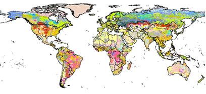
The HWSD is a 30 arc-second raster database with over 16000 different soil mapping units that combines existing regional and national updates of soil information worldwide (SOTER, ESD, Soil Map of China, WISE) with the information contained within the 1:5 000 000 scale FAO-UNESCO Soil Map of the World (FAO, 19711981). The resulting raster database consists of 21600 rows and 43200 columns, which are linked to harmonized soil property data. The use of a standardized structure allows for the linkage of the attribute data with the raster map to display or query the composition in terms of soil units and the characterization of selected soil parameters (organic Carbon, pH, water storage capacity, soil depth, cation exchange capacity of the soil and the clay fraction, total exchangeable nutrients, lime and gypsum contents, sodium exchange percentage, salinity, textural class and granulometry). Reliability of the information contained in the database is variable: the parts of the database that still make use of the Soil Map of the World such as North America, Australia, West Africa and South Asia are considered less reliable, while most of the areas covered by SOTER databases are considered to have the highest reliability (Central and Southern Africa, Latin America and the Caribbean, Central and Eastern Europe). Further expansion and update of the HWSD is foreseen for the near future, notably with the excellent databases held in the USA: Natural Resources Conservation Service US General Soil Map (STATSGO), Canada: Agriculture and AgriFood Canada: The National Soil Database (NSDB) and Australia: CSIRO, aclep, natural Heritage Trust and National Land and Water Resources Audit: ASRIS. DISCLAIMER The designations employed and the presentation of materials in Harmonized World Soil Database do not imply the expression of any opinion whatsoever on the part of the Food and Agriculture Organization of the United Nations (FAO) the International Institute for Applied Systems Analysis (IIASA), International Soil Reference and Information Centre (ISRIC), Institute of Soil Science – Chinese Academy of Sciences (ISSCAS) or Joint Research Centre of the European Commission (JRC) concerning the legal status of any country, territory, city or area or its authorities, or concerning the delimitation of its frontiers or boundaries. © 2008-2012 COPYRIGHT FAO, IIASA, ISRIC, ISSCAS, JRC Citation |
|||||||||||
|
Further information on the supplementary datasets can be obtained from the Land Use Change and Agriculture Program, International Institute for Applied Systems Analysis (IIASA)
Phone: (+43 2236) 807 0 |
|||