

Research projects
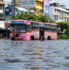
Flood Resilience
IIASA is a core member of the Flood Resilience Alliance, an innovative partnership between research, development and humanitarian NGOs and the private sector that works together for making at step change with regard to policy, finance and practice of managing floods and other climate-related hazards towards increased community resilience. More

LandSense: A Citizen Observatory and Innovation Marketplace for Land Use and Land Cover Monitoring
How can citizen-powered science coupled with mobile technology improve our understanding and governance of land use and land cover changes? More
RESTORE+: Addressing Landscape Restoration on Degraded Land in Indonesia and Brazil
RESTORE+ aims to explore restoration and utilization options of tropical degraded and/or marginal land in order to ease pressure on deforestation as well as mitigating climate change. The project aspires to generate innovative methodology that combines multi-objective modelling (utilizing more than five in-house and newly developed models) with advanced big data and crowd-empowered remote sensing analyses. More

Nature Map Earth
Nature Map Earth is developing an integrated global map of biodiversity, carbon storage, and other dimensions of nature by consolidating and crowd-sourcing data from many sources. More
EuroGEOSS Showcases: Applications Powered by Europe (e-shape)
The Horizon 2020-funded EuroGEOSS Showcases: Applications Powered by Europe (e-shape) project is an unprecedented initiative that brings together decades of public investment in earth observation and in cloud capabilities into services to the citizens, the industry, the decision-makers and the researchers. More
EuropaBON
European countries and regions have invested substantial amounts of resources into biodiversity conservation and knowledge. However, there continues to be limited availability at the EU-scale of harmonized, long-term, spatially explicit and regularly updated biodiversity data. This limits the uptake by policies and sectors that have an impact on biodiversity or that can mitigate biodiversity loss. How will EuropaBON address this challenge? More


Picture Pile Platform
The ERC PoC project Picture Pile Platform is an innovative, commercially self-sustaining platform that uses the crowdsourcing game Picture Pile for efficiently and intuitively classifying images for machine learning. It will offer a standardized, easy-to-use way for everyone to freely and quickly set-up their own picture pile campaigns for collecting image classifications by the crowd in a gamified environment, where participation is incentivized through extrinsic and intrinsic motivations. More
RapidAI4EO
RapidAI4EO aims to advance rapid and continuous land monitoring with state-of-the-art AI solutions. Under the sponsorship of the European Union’s Horizon 2020 program, RapidAI4EO will establish the foundations for the next generation of Copernicus Land Monitoring Service (CLMS) products. More

World Cover
World Cover aims to produce, deliver and validate, as fast as possible, a global land cover map at 10m resolution with a mapping of a minimum of 10 land cover classes and a minimum overall accuracy of 75 %. The project is user driven, aiming at a maximum impact of the global land cover map to a set of end-user organizations. More
Helmets labeling crops
The Helmets Labeling Crops project will implement novel and innovative approaches that include rapid point data collection combined with crowdsourcing to create point and polygon labels using tested software tools to create an machine learning ready label dataset More
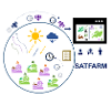
SATFARM Services
SATFARM Services aims to derive new remote sensing indicators of climate-smart agricultural practices that provide enhanced resilience in the face of weather extremes resulting of climate change More

NODES completed projects
PUBLICATIONS