

Global Cropland Mapping: Release of First Hybrid Cropland Map
A new global cropland map has been created at a resolution of 1km within the framework of the Geo-Wiki project.
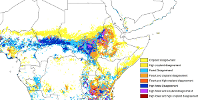
The global product was initiated at a 2010 IIASA land cover mapping workshop to address the lack of reliable information on cropland. It has been created from a number of different national, regional, and global land cover products, and then calibrated with national and subnational crop statistics. It currently contains national products from 25 countries worldwide (see list of contributing countries) and will be updated as more countries contribute data. This branch of Geo-Wiki is also being used to crowdsource feedback from experts to continually improve this new global product.
The global hybrid cropland map is currently being used by IFPRI to create global crop type distribution maps using their SPAM model. These inputs will be used in global models to evaluate land use policies, explore long-term sustainability options, and better evaluate trade-offs between, for example, food and biofuel feedstock production or between biofuel production and afforestation projects.

Related Links
Main Cropland Mapping Partners
Global and National Dataset Providers