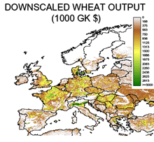
Global change processes raise new estimation problems challenging the conventional statistical methods. While the latter are based on the ability to obtain a large number of observations from unknown true probability distributions, the new problems require recovering information from only partially observable or even unobservable variables. For instance, aggregate data exist at global and national level regarding agricultural production. ‘Downscaling’ methods in this case should achieve plausible estimation of global distributions, consistent with ‘local’ data obtained from remote sensing and available aggregate statistics, by using all available evidence and technical knowledge.
Initially a flexible sequential downscaling method, based on iterative rebalancing, was developed by LUC and implemented for use in connection with GAEZ 2009.
Subsequently more generic sequential downscaling and up-scaling procedures were developed to address problems of data scarcity and incompleteness and to deal with data heterogeinity at required spatio-temporal scales. The procedures rely on an appropriate optimization principle and combine the available observations in locations with other “prior” hard and soft data (expert opinion, scenarios), pseudo-sampling models, evidence on the related variables that exist in the form of interdependent observable, partially observable or indirectly observable and non-observable variables on various scales.
In practical applications, the choice of an initial or prior distribution is at the core of the downscaling methodology, ultimately determining the success of these procedures. A key issue is treatment of uncertainties in priors and the parameterization of constraints.
Sequential rescaling procedures can be used in a variety of practical situations. Extensive testing of the methodology for instance for downscaling of agricultural crop production and for sustainable livestock allocation, has demonstrated that the iterative downscaling procedures are converging fast, allow for great geographical detail and are very flexible in model specification and detail.
Responsible for this page:
Elisabeth Kawczynski
Last updated:
24 Feb 2011
![]()


 Schlossplatz 1