
Copyright © 2002, IIASA & RAS
All Rights Reserved
 Land
is "an area of the earth's solid surface, the characteristics of
which embrace all reasonably stable, or predictably cyclic, attributes
of the biosphere vertically above or below this area, including those
of the atmosphere, the soil and underlying geology, the hydrology, the
plant and animal populations, and the results of past and present human
activity." (FAO, 1976). Land is a living, basic support system that
supplies most living forms with the space, energy, and nutrients essential
for all the biochemical metabolisms occurring in any organism. Land also
plays a key role in major biogeochemical cycles within ecosystems and
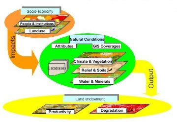
globally. Two major domains are generally associated with land: (1) natural
conditions and (2) land endowments displaying various consequences of
anthropogenic intervention (see accompanying figure). The term "land
quality" refers to the natural capability of land to meet certain
anthropogenic activities in a broad sense. Land quality is traditionally
interpreted in terms of land resources. Throughout time, people have exploited
land in different ways, ranging from simple watching of landscapes and
primitive collection of herbs to intensive land management in which land
was massively distorted by heavy machinery and artificially generated
industrial areas.
Land
is "an area of the earth's solid surface, the characteristics of
which embrace all reasonably stable, or predictably cyclic, attributes
of the biosphere vertically above or below this area, including those
of the atmosphere, the soil and underlying geology, the hydrology, the
plant and animal populations, and the results of past and present human
activity." (FAO, 1976). Land is a living, basic support system that
supplies most living forms with the space, energy, and nutrients essential
for all the biochemical metabolisms occurring in any organism. Land also
plays a key role in major biogeochemical cycles within ecosystems and
globally. Two major domains are generally associated with land: (1) natural
conditions and (2) land endowments displaying various consequences of
anthropogenic intervention (see accompanying figure). The term "land
quality" refers to the natural capability of land to meet certain
anthropogenic activities in a broad sense. Land quality is traditionally
interpreted in terms of land resources. Throughout time, people have exploited
land in different ways, ranging from simple watching of landscapes and
primitive collection of herbs to intensive land management in which land
was massively distorted by heavy machinery and artificially generated
industrial areas.
These two poles are different human strategies: to adapt ourselves to
the land's capacity, on the one hand, or to rebuild land to fit peoples'
demands. These strategies could be also considered from an evolutionary
perspective. Human beings wish to be more secure and less vulnerable to
natural cataclysms. Over time, some societies become better armed to manage
natural processes. This path has different consequences and all of them
must be deeply studied in order to maximize benefits and minimize obvious
losses. The major question of how society should maintain and enhance
the potential of land resources and mediate environmental degradation
remains open. Many scientific and practical institutes are looking for
an appropriate answer and have gained a lot of achievements. There is
a crucial need to develop a tool for exchanging and extrapolating accumulated
knowledge.
This CD-ROM intends to approach the problem from a systems-analytical
perspective. We believe that information on the proper use of land resources
should be reliable and easy to use. It should be captured and handled
by modern analytical tools. The concept we suggest for such an information
system is to establish land attributes in a traditional three-dimensional
fashion: socioeconomic, natural characteristics, and land endowments (see
accompanying figure). By examining spatially explicit interactions between
these aspects we are able to discover combinations that minimize conflicts,
to make the most efficient trade-offs, and to link social and economic
development with environmental protection and enhancement. The CD-ROM
is in line with Chapter 10 of Agenda 21, as adopted by the Plenary in
Rio de Janeiro, on 14 June 1992, which calls nations toward an integrated
approach to the planning and management of land resources and contributes
to achieving the objectives of sustainable development.
The goal of this CD-ROM is to answer the need for comprehensive data on
the land characteristics of Russia. The data included have been specially
selected and filtered to meet the following criteria: (1) completeness:
to meet a variety of the analysis tasks; (2) complexity: to describe a
diversity of the task aspects; (3) consistency: to provide compatible
results; to be at a compatible scale and, to provide a compatible time
horizon;and (4) uniformity: to allow them to be standardized and formatted
according to modern data handling routines.
The principle of geographic uniqueness makes impossible any mechanical
extrapolations of land use practices from one region to another. In addition,
each country has its own socioeconomic environments and traditions in
measurements and terms of land inventory and use. This raises the problem
of the fluency of information exchange. Is it possible to share "good
practices"? The major data of this CD-ROM can be converted into worldwide
formats, connecting local experience with that of other countries. This
approach provides a key to the challenging analysis and helps users find
solutions that better match regional and local goals.
Reference
FAO. 1976. A Framework for Land Evaluation. Soils Bulletin No. 32. FAO,
Rome and ILRI, Wageningen. Publication No. 22.79.