Copyright © 2002, IIASA & RAS
All Rights Reserved
The following is an alphabetical listing of all scientific terms (with an explanation of their meaning), used in the Land Resources of Russia CD-ROM. Some words in the text were highlighted with bold and these appear in the glossary.
|
Term |
Explanation |
|
Aapa bogs |
Herb/sphagum/hypnum bogs |
|
Advection |
Transfer of air and its properties in a horizontal direction. There is advection of the air masses, and the atmospheric phenomena known as advection fog, advection thunderstorm, advection frost, etc. |
|
Air continental |
A mass of air, usually of fairly low moisture content, which remains over a continent for several days and changes its properties under influence of the underlying surface of the land. |
|
Alas |
Relief form. A large flat-bottomed depression (kettle-hole) in a permafrost area that results from the melting of underground ice. From the Yakut language. |
|
Albedo |
A quantity, which characterizes the reflective capability of any surface (clouds, vegetation, sea surface, etc.). It is determined as a ratio of the radiation (radiant or luminous energy) reflected by a surface to that incident on it. Albedo is expressed as a percentage or in parts of unit. |
|
Aluminosilicates |
Minerals of a group of silicates. Aluminosilicates form a tetrahedron, in which a part of silicon is replaced by aluminum. In addition to silicates and aluminum they contain calcium, potash, or sodium. |
|
Anticyclone |
The region of increased pressure in the atmosphere where the pressure is maximal in the center, and the atmospheric pressure gradient is directed from the center to the periphery. Downward air motions prevail in an anticyclone, and therefore clear, dry weather usually dominates as well. |
|
Aufeis (also, naled) |
An ice layer being formed as a result of layer-by-layer freezing of river or underground water which has poured out onto the surface, or it takes place in a cavity of rocks due to pressure load of underground or surface waters at a freezing-through of river beds or a water-bearing horizons. |
|
Balka (Syn. Log) |
Relief form. A dry valley or one with a temporary water stream. It has a gentle-concaved bottom and sod-covered bulge slopes with steppe vegetation. |
|
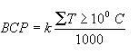
Bioclimatic potential |
A complex index for assessment of land productivity based on moisture and heat provision. It is calculated according to the following formula:
where BCP is
a relative number of bioclimatic potential, k is a coefficient of
bioproductivity, and |
|
Biodiversity |
The variety and variability among living organisms from all sources including, inter alia, terrestrial, marine, and other aquatic ecosystems and the ecological complexes of which they are a part. This includes diversity within species, and between species and ecosystems (Convention on Biological Diversity, Rio de Janeiro, Brazil, 1992). |
|
Biohydrothermic potential |
A complex index to calculate potential land productivity of agricultural crops. The following formula proposed by A.M.Riabchikov is used for calculation:
Where Kp is amount of biohydrothermic potential of crop capacity; W is a productive moisture (mm); Tv is a vegetative period (decades); R is a radiative balance over this period (kcal/cm2). |
|
Biome |
Group of ecosystems that have a similar structure or physiography and common environmental conditions. |
|
Block streams |
Linear stretched accumulation of big stones slowly moving downwards under gravitation. Common for East Siberia, Zabaikalie, Sayani, and other regions with continental climate. |
|
Bulgunnyakh |
Perennial mound of cryogenic heaving caused by irregular ice-formation when taliks freeze and permafrost is formed. From Yakut language. |
|
Catagenesis |
A stage of lithogenesis. Catagenesis, alongside with diagenesis, relates to a group of epigenetic changes of adjournment and rocks. Catageneic changes occur at high temperature and pressure under relatively thick rock. |
|
Catchment (drainage) area |
A territory from which waters run into a river or water reservoir. |
|
Causative factor (degradation) |
Kind of human action that can be considered responsible for the occurrence of the degradation type involved. |
|
Circulation meridional |
Component of the atmospheric circulation along a meridian towards the north or south. It promotes the air inter-latitude exchange. |
|
Clearings |
Open sites of non-forest lands located within a forest, covered with grasses and herbs. As a rule, used for recreational purposes. |
|
Climate |
The long-term regime of the atmospheric conditions typical for a concrete region (territory). Notions about the climate are based on a statistical collection of long-term meteorological observations of the following quantities: the atmospheric pressure, the wind velocity and direction, the heat balance of the earth's surface, the air temperature and humidity, cloudiness, and the atmospheric precipitation. |
|
Coarse woody debris |
Organic matter that is accumulated in the dead above-ground (standing dry trees, dry branches of live trees, stumps) and on-ground (downed wood, windbreak, etc.) wood. |
|
Compaction |
An increase of soil bulk density by more than 1.2 times as compared with those of natural soil. |
|
Continentality (climate) |
The degree to which a region on the earth's surface is in all respects subject to the influence of a land mass, i.e., its climate features. These are increased annual and daily amplitudes of the air temperatures as compared with oceanic regions, increased inter-diurnal variability of the temperature and its anomalies for different time periods, decreased relative humidity and cloudiness in summer and during the day, greater than in ocean variability of precipitation and general decrease of precipitation, smaller wind velocities. |
|
Continentality (index) |
Numerical characteristics of the climate continentality. It is based on a function expressing the annual range of the air temperature. Sometimes the continentality index is presented as a function of latitude, annual and daily temperature amplitude, and of the moisture deficit in the driest month. |
|
Cropland (arable land) |
Lands permanently used for growing agricultural crops and vegetables. |
|
Dead above-ground phytomass |
On-ground organic matter from the annual death of parts of the plants, organisms, natural thinning, forest and shrubs and grasses litter, peat soil horizon, etc. |
|
Dead below-ground phytomass |
Organic matter from the death of below-ground parts of the plants (roots, rhizomes, tubers, and bulbs). |
|
Deflation |
Loss of topsoil, disturbance of rocks and soils by the wind, accompanied by removal and grinding of soil particles. |
|
Degradation |
Process that describes human-induced phenomena that lower the current and/or future capacity of the soil to support human life. |
|
Desertification |
Expanding areas of deserts as a result of natural (cyclic changes in climate) and anthropogenic (wood cutting, removal of herbaceous vegetation due to overgrazing) causes. |
|
Diagenesis |
A stage of lithogenesis. It follows adjournment of a deposit under normal or not so high temperature and pressure. |
|
Drought |
A combination of meteorological factors leading to water deficit and causing water stress for plants or even their death. |
|
Evaporation |
The physical process by which a liquid or solid state is transformed to the gaseous state (a vapor). In nature, water vapor comes into the atmosphere from surfaces of water, soils, snow, ice, vegetation, and so on. |
|
Farmsteads |
Plots of nonforest lands with service and residence buildings, of managerial and communal purposes for employees and workers of forest management (offices of FMUs and forest districts, stores, yards, garages, workshops, dwellings, as well as lands under settlement, rest facilities (campings, tents, rest bases, etc.), and those with elements of recreational facilities. |
|
Flood (high water) |
Rapid and comparatively short-term rise of the water level in a river. It is usually caused by the rains. Unlike a spring flood it arises irregularly. |
|
Flood spring (high water) |
Yearly and usually long water rise in rivers caused by snow melting on plains or by melting of snow and ice in mountains. |
|
Forest age group |
Organizing of forest stands into age groups, depending on final cutting age and on duration of their age class. They include: young stands, middle-aged, maturing, mature, and overmature. |
|
Forest, burned |
Plots of forest lands occupied by forests damaged by fires up to the degree of stopping growth. |
|
Forest compartment (Rus. kvartal) |
A parcel of a forest massif delimited on the terrain by rides or natural and artificial boundaries that serves as a permanent account and management unit in the forest. |
|
Forest cultures |
Plots of artificial forest stands created by planting or sowing. This category also includes forest plots where one has finished the stands' reconstruction, done with the purpose of improving their species composition by introducing economically valuable tree species. |
|
Forest cut-overs |
Plots of forest lands occupied by a felling area where trees have been cut down and young stands have not yet closed its canopy. |
|
Forest district (Rus. lesnichestvo) |
Primary territorial and operational subunit constituting the forest management unit. |
|
Forest evaluation stratum (Rus. vydel) |
Primary inventory and planning and management unit. A part of the compartment that is quite homogeneous as regards its space and managerial value and evaluation parameters, distinguished from neighboring blocs and requiring unified methods of management. The size of strata depends on their inventory and planning class: for the 1st class - 3-5 ha, for the 2nd - 6-15 ha, for the 3rd - 16-35 ha. |
|
Forest, exploitable |
Mature and overmature stands that may be allotted to final harvesting |
|
Forest glades |
Open sites of forest lands without trees or with isolated trees within a closed canopy forest, formed by blowdown, windbreakage, snow-breakage, fires, clear-cutting, etc. |
|
Forest group |
As provided by the forest legislation of the Russian Federation, a part of the Forest Fund differentiated by economic destination, location, and functions to be performed. There are three forest groups. |
|
Forest growing stock |
The volume (in m3) of living trees' trunks available in a given forest stand. |
|
Forest inventory |
Identification and delimitation of all the economic categories of areas within a compartment, determination of each plot (stratum) on planchette and on plan of stands, as well as drawing up evaluation characteristics for each plot. |
|
Forest inventory and planning operations |
A complex of operations for forest inventory in forest management units and drawing up on this basis a project for running the forest manage-ment. Such operations are carried out annually - on the average - on 17 million ha (formerly - on 48 million ha). They have to be performed in all forest management units at the interval of 10-12 years or 15-20 years, depending on precision class. |
|
Forest lands |
Lands suitable and intended for forest growing, as well as natural scarce open woodlands and shrubs. |
|
Forest management unit (FMU), (Rus. Leskhoz) |
The basic element of the state management of forestry in the Russian Federation. Legal person. Subordinated to authorized bodies of the state forest management of the Federation's members. By January 1, 1998, there were 1,826 FMUs. |
|
Forest mature stand |
Forest stand that has reached the fixed cutting age. |
|
Forest maturing stand |
Forest stand of one or two age classes preceding the cutting age. |
|
Forest middle-aged stand |
Forest stand being at the age period beginning by the 3rd age class up to maturing stage. |
|
Forest non-closed cultures (not reclassified in lands covered with forest vegetation |
Plots of forest cultures that have not reached the stage of crown (storey) closing. |
|
Forest nurseries |
Plots of forest lands used for growing planting material (seedlings and transplants) for creating forest cultures. |
|
Forest over-mature stand |
Forest stand with mean age exceeding the cutting age by two and more age classes. |
|
Forest plantations |
Plots of forestlands used for growing tree and shrub species with the purpose of obtaining valuable timber assortments (plantations of maple, willow, cork tree, oaks, etc.). |
|
Forest stand |
Totality of living trees that are the basic component of forest. |
|
Forest standing volume |
Amount of wood in volume units (m3). |
|
Forest stands perished |
Plots of forest lands occupied by drying out forests damaged by pests, industrial emissions, wetting, recreation overloading, and other negative factors, as well as plots damaged by continuous blow down, wind breakage, snow-breakage. |
|
Forest State Account |
Updating statistical data on Forest Fund in forest management units and their further generalization in accordance with the established administrative and geographical accounting categories. |
|
Forest total mean increment of growing stock |
Amount of wood increased over a calendar year. |
|
Forested lands (forest covered lands) |
Forest lands occupied with young stands of 0.4 density and elder stands of 0.3 and higher densities, as well as shrubs of 0.4 and higher densities on lands unsuitable for growing tree species forest, or in cases of organizing special management units for shrub species (sea buckthorn, hazel, willow, and others). |
|
Frost killing |
Death of crops or their parts due to severe frost, causing formation of ice crystals in the tissues. Ice crystals disturb the plant tissues (leaves, stems and roots). Dehydration of the cytoplasm results in structural disturbance, albumen coagulation leads to death. |
|
Frost mound |
A hummock (hillock) in cryogenic topography caused by irregular ice-formation in mountain rocks. |
|
Frost-free period |
Generally, the period of the year between a mean date of the last frost in spring and a mean date of the first frost in autumn. During this period the temperature of cultivated vegetation remains sufficiently high to allow plant growth, i.e., it determines the cultivation possibilities in a given region of certain plants. |
|
Gardens, vineyards, fruits, and nuts plantations |
Plots of non-forest lands used for fruit gardens, growing vines, fruits, and nuts and berries |
|
Glacier |
Natural accumulation of ice and firn slowly flowing over the earth's surface resulting from consolidation and transformation of solid atmospheric precipitation under its long-term positive balance. (A mass of land ice, formed by the further re-crystallization of firn, flowing slowly (at present or in the past) from an accumulation area to an area of ablation. |
|
Golets |
Mountain flat non-vegetated top above tree line in vertical vegetation zonality. Common for moderate cold climate Polar Ural, mountains of East and South Siberia. |
|
Grasslands |
A group of ecosystems with the predominance of grasses, mainly of mesophylous and xerophylous species. Meadows and steppes are the major types of these communities. |
|
Grivas |
Relief form. Low height narrow uplands of various origin (accumulative, glacial, denudative, gravitate). Can occur solely, or form a specific group (grivas relief). |
|
Hayland (hay-fields) |
Lands permanently used for growing grasses and herbs. |
|
Heat resources |
Heat available for vegetation period. Temperatures accumulated effective and minimum effective are usually used to define this parameter. |
|
Highland (high plateau) |
Extensive areas on the earth's surface highly elevated above the sea level. They are characterized by a combination of mountain ranges, massifs, and tablelands, sometimes alternating with wide flat depressions. |
|
Humidification |
Relation between the amount of precipitation received and the amount of water evaporated from the water surface at a given region. |
|
Humidification coefficient |
Ratio between precipitation and evaporation expressed in relative value and characterizing climate humidity, i.e., the humidity coefficient is more than 1.0 for humid climates for which precipitation exceeds evaporation. Climate is considered to be semiarid and arid if the humidity coefficient is less than 1.0, i.e., precipitation is below evaporation rate. |
|
Hydrolaccolith |
Perennial mound of frost heaving emerging in surface areas of underground water outcrop or circulation in a course of its freezing. |
|
Hydrothermic coefficient |
|
|
Ice content (permafrost rock) |
The degree to which a rock is saturated with ice, in general or with a certain type of ice. |
|
Ice formation |
Formation of ice from snow and firn resulting from sublimation re-crystallization and melting as well as from the congelation of ice when water freezes. |
|
Ice latent content |
Underground ice forming very small inclusions, which cannot be directly measured. |
|
Ice vein repeated massive |
Ice of repeated ice veins results from oft-repeated frost fracturing and refilling of fractures with ice. |
|
Impact on productivity |
Change of productivity as compared with the average productivity of the nondegraded (nonimproved) soil. |
|
Inversion |
Distribution of one or another quantity with height opposite to its normal distribution. For instance, it can be the temperature increase with height in a certain layer of the atmosphere, or a decrease of precipitation amount with height in mountains starting with a certain altitude. |
|
Irrigation |
Artificial moistening of soil aimed at providing plants with more moisture as well as regulating a salt regime of salted soils; one of the types of soil reclamation. |
|
Isotherm |
A line joining points of equal temperatures of air, water, soil, etc. |
|
Kolki |
Group of trees in the steppe zones of West Siberia formed on the shallow round-shaped depressions. |
|
Kvartal |
See Forest compartment. |
|
Leskhoz |
See Forest management unit. |
|
Lesnichestvo |
See Forest district. |
|
Littoral vegetation |
Plant communities of the tidal zone of the seas or the coastal zone of freshwater bodies. |
|
Litter |
Long-term deposits of plant residues of various states of mineralization at the soil surface. |
|
Litter fall annual |
Organic matter of the falling parts of trees, shrubs, i.e., the leaves (needles), flowers, paleas, fruits, seeds, small shoots, etc. |
|
Lowland |
Flat plain whose height is below 200 m above sea level. |
|
Managerial lands |
Nonforest lands intended mainly for agricultural use and water bodies of all kinds. |
|
Mari |
Mosaic of swampy (mainly sphagnum) sparse larch forest in East Siberia and the Far East with treeless bogs and swampy shrubs (Betula nana, etc.). |
|
Maritime (oceanic) mass of air |
Mass of air being formed or transformed over the sea surface. It differs from the continental mass of air of the same latitude zone by increased moisture content, reduced daily amplitude of the temperature, etc. |
|
Meadows |
Group of polydominant communities with a prevalence of perennial grass mesophytes. The meadows perform under sufficient water supply and occupy sites with various soils having a specific grass sod topsoil horizon. |
|
Metamorphism |
Stage of lithogenesis, resulting in mineralogical, structural, and textural transformations of rocks, occurs at high temperature and pressure. |
|
Mineralogy |
Natural science studying minerals of deposits, rocks, and soils; conditions and processes of formation, transformation and destruction of minerals. A special aspect of mineralogy is the geography of minerals and their associations. |
|
Moisture-supply |
Amount of water available to plants. Soil moisture, atmospheric moisture (ratio between annual amount of precipitation and accumulated average daily air moisture deficit), and coefficient of bioproductivity are the major indicators of moisture-supply of the crops. |
|
Monsoon summer |
The summer part of a specific regime of air flows over a significant area of the Earth's surface, which is characterized by a seasonally persistent wind direction, and by a pronounced change in direction from one season to another. This circulation has features of a breeze. In the middle latitudes it brings a predominance of low atmospheric pressure and bad weather. It is noticeably pronounced in the Far East, where south and southeast monsoon winds prevail in summer. |
|
Monsoon winter |
The winter part of a specific regime of air flows over a significant area of the Earth's surface, which is characterized by a seasonally persistent wind direction, and by a pronounced change in direction from one season to another. This circulation has features of a breeze. In the middle latitudes it brings a predominance of the anticyclone weather. It is noticeably pronounced in the Far East, where northern and northwest monsoon winds prevail in winter. |
|
Mountains |
Fold and fold-blocked structure of the Earth's crust, which is elevated up to several thousand meters above sea level and characterized by sharp changes of altitudes within their boundaries. Morphologically, mountains are classified as high, middle, and low. The altitudinal zonality of landscape caused by the climate alteration with height is typical for mountains. |
|
Mountain treeless abrupt slopes |
Mountain slopes (steepness mainly over 30%), the natural conditions of which are unsuitable for forest vegetation. |
|
Naled (also, Aufeis) |
An ice layer being formed as a result of layer-by-layer freezing of river or underground water which has poured out onto the surface, or it takes place in a cavity of rocks due to pressure load of underground or surface waters at a freezing-through of river beds or a water-bearing horizons. |
|
Nonforest lands |
Lands not suitable for forest growing or suitable only after special reclamation measures, as well as lands of special management assignment. |
|
Ontogenesis |
Development of an organism from its appearance to the end of its life cycle. The stages of ontogenesis of plants are: embryonic, juvenile, ripeness, reproductive, and old age. |
|
Ouval |
Relief form. Stretched upland with gentle slopes and lack of foothills. The top is flat or slightly bulged. Relative height about 200 m. |
|
Overmoisturing |
Death of crops due to excess water, e.g., flooding. Overmoisturing takes place in spring, or in depressions, where the water stays at the soil surface for a long time. Soil fauna die because of a deficit of oxygen and the plants die because of a shortage of nutrients and oxygen. |
|
Padi |
Relief form. U-shaped valley where mountainous and plain reliefs meet in Zabaikalies. |
|
Palynological spectrum |
A ratio between spores and pollen of various plant species found at various depths of the soil profile. |
|
Parent rocks |
Geological material (deposits and rocks of different types), from which the soils are formed. |
|
Pastures |
Lands permanently used for cattle grazing. |
|
Permafrost |
Rocks with temperature below 0oC. Permafrost is the main component of the frozen zone of the lithosphere and remains frozen for tens, hundreds, and thousands years. |
|
Petrography |
Natural science studying mineralogical composition, structure, texture, and chemical composition of the rocks. |
|
Phenology |
Seasonal rhythm of plant and plant community development. |
|
Phytocoenosis |
Community of plant species at a certain site, which are functionally interrelated with each other and with the environment. |
|
Phytomass, above ground |
Total amount of live vegetative organic matter that has been accumulated in the above ground part of the community. |
|
Phytomass, below ground |
Total amount of live vegetative organic matter that has been accumulated in the underground part of the community. |
|
Plain |
Earth's surface, which is characterized by level slopes and insignificant variations of altitudes within 200 m above sea level. |
|
Precipitation (annual) |
Sum of liquid and solid precipitation measured at a given site for the calendar year. |
|
Precipitation (atmospheric) |
Any (liquid, solid, or mixed) form of water particles that fall from the atmosphere and reach the ground. It is a major class of hydrometeor; but it is distinguished from cloud, fog, dew, rime, frost, etc. in that it must fall; and it is distinguished from cloud and virga in that it must reach the ground. The forms of precipitation are: rain, drizzle, snow, snow grains, snow flakes, snow pellets, diamond dust, hail, and ice pellets. |
|
Production, gross biological (GBP) |
The rate of accumulation of organic matter that is produced by the autotrophs in the course of photosynthesis. |
|
Production, net primary (NPP) |
Increase of phytomass over a unit of time per unit of area minus a certain amount of organic material used to maintain the life of producers; the amount of dead phytomass; the amount of phytomass consumed by various heterotrophs; and also the excreta of the roots and above-ground organs of the plants. |
|
Protection measures |
Activities which are done to protect soils against degradation. |
|
Radiation balance (net radiation) |
Algebraic total of the radiation fluxes absorbed and radiated by the atmosphere. Its income part is composed of the direct and diffuse solar radiation absorbed in the atmosphere, together with the long-wave (LW) radiation of the atmosphere itself. Its expense part is the LW radiation of the atmosphere coming to the earth's surface (downward LW radiation) and that going out into space (outgoing LW radiation). (The difference between the downward and upward fluxes of [solar and terrestrial] radiation is incident, reflected, or scattered.) |
|
Radiation, direct (solar) |
Solar radiation is a form of parallel solar rays coming to the Earth directly from the Sun. It changes with respect to the Sun's altitude and the transparency of the atmosphere. |
|
Radiation, photosynthetic active |
Solar radiation in the range of 380-710 nm, which is used by the plants for photosynthesis. |
|
Rate of soil degradation |
Degradation trend during the last 5-10 years. |
|
Retardants |
Chemical compounds, alone or in combination, used for control over the growth and development of plants. |
|
Roads |
All kinds of roads of common use and special forest roads on Forest Fund lands. |
|
Rocks |
Outcrops of stony rocks with steep or vertical slopes and pointed tops. |
|
Rotting away |
Weakening or death of winter crops in spring under a deep snow cover because of exhaustion and mold attack. The plants renew vegetation under snow cover. They consume nutrients, but, unable to replenish them because of shortage of light and air, they become exhausted and die. |
|
Runoff (annual) |
Total volume of water flowing down during the year, usually related to a closing discharge section line of a water catchment or a river basin. |
|
Runoff layer |
A water volume flowing down from a catchment area for some time period related to its area. It is usually expressed in mm. |
|
Runoff surface |
A part of the total river runoff, which is formed on a catchment area surface. |
|
Runoff total |
Amount of water running in the riverbed for some time period. It consists of surface and underground components. |
|
Runoff underground |
A part of the total river runoff, which is formed in the underground soil horizons. |
|
Sands |
Non-forest lands occupied by unvegetated sands. |
|
Secondary salinization |
Human-induced salt accumulation in the upper part of the soil profile, resulting from evaporation of irrigation groundwater in capillary fringe due to rise of the groundwater table. |
|
Sewage (waste water) |
Used water, which is returned into water sources. Usually it is of a low quality due to contamination. |
|
Scrublands |
Vegetation communities with dominating shrubs. |
|
Snow cover duration |
Mean time between the moment of the snow cover formation and its melting. |
|
Snow cover loss |
End of the period during which the snow cover remains on the earth's surface. |
|
Snow density |
Ratio of the mass of a snow sample to its volume. |
|
Snow drifting (snowstorm) |
Snow transport by wind over the surface of soil or snow cover. Ranges from drifting snow (the visibility is not sensibly diminished at eye level), to low snowstorm (with very low visibility in it), to total snowstorm. |
|
Snow storage (maximal variability) |
Climatic characteristics of nonperiodic variation of maximal snow storage in a given area. |
|
Soil aggregate (Syn.: Ped) |
Soil particle of complicated composition formed from microaggregates or individual mineral grains due to adhesion under the influence of physical, chemical, physicochemical, and biological processes. They are subdivided by complexity, shape, and size. |
|
Soil cartography |
Branch of soil science studying methods of soil mapping and spatial analysis. |
|
Soil classification |
Systematic arrangement of soils into groups and establishment of hierarchy among them. |
|
Soil consistence |
The character of the finest soil particles and aggregates and corresponding breaking and shape of pores. |
|
Soil fertility |
Combination of soil characteristics supporting the production of agricultural crops. There is (1) natural (potential) soil fertility that is conditioned by the reserves of fertile substances and natural water-air soil regimes and (2) effective soil fertility that is characterized by a higher content of available fertile substances (application of fertilizers) and better (amelioration) conditions for crop growth (water, air, and heat provision). |
|
Soil-forming factors |
Compartments of nature influencing soil formation. Theses are: soil-forming rocks, live and dead organisms, climate, age and forms of relief, anthropogenic activity. |
|
Soil-forming process |
Process leading to soil formation from parent rock under the influence of live and dead organisms and products of their metabolism and breakdown. Soil is formed on the border of the lithosphere and biosphere and results from their interaction. In addition, the atmosphere and hydrosphere also participate in soil formation. Solar energy is the main source for the soil-forming process. The latter occurs in the gravitation influence of the earth. The soil-forming process includes a variety of chemical, physical, and biological phenomena. Humans currently have an important and direct effect on soil-forming process. |
|
Soil geography |
Branch of soil science studying regularity of spatial soil distribution in relation to natural conditions (see soil-forming factors). |
|
Soil mantle structure |
Regularity of spatial distribution of genetically associated soil of the finest units performing a specific configuration. |
|
Soil morphogenetic horizon |
Relatively homogeneous soil layer formed as a result of the soil-forming process and lying parallel to the earths surface. Horizons differ from each other and from parent material by color, structure, consistency, chemical composition, new formations, etc. Horizons result from additions, losses, transfers, and transformations of energy and matter, migration, carrying-out and transformation of substances in soil. |
|
Soil profile |
Sequence of interrelated morphogenetic soil horizons. |
|
Soil science |
Soil science is an independent natural science that studies soil, its origin, formation, morphological features, chemical composition and characteristics, regularities of distribution across the earths surface, fertility, and use. |
|
Soil storage (minimum) water capacity |
Amount of water in a certain soil layer after the draining of the excessive gravitational moisture and under the lack of the groundwater effect. |
|
Soil structure |
The shape and size of aggregates of naturally breaking soil. |
|
Soil texture |
The proportion (percent by weight) of mineral particles of different size. |
|
Soil zone |
Area dominated by zonal soil type and associated interzonal soils. Soil zone is a taxon of soil regionalization. |
|
Stable under human influence |
This influence may be passive, i.e., no special measures had or have to be taken to maintain stability, or active: measures have been taken to prevent or reverse degradation. |
|
Stable under natural conditions |
Absence of human influence on soil stability, and largely undisturbed vegetation. |
|
Stable without vegetation |
Absence of human influence on soil stability, e.g., deserts, high mountain zones. |
|
Steppes |
Polydominant grass communities dominated by xerophylous plants, mainly bunch-grasses. They are characterized by well-developed rizosphere and prevalence of below-ground phytomass. |
|
Surface corrosion |
Displacement of soil material of permafrost soils (solifluction, mudboiling, hummocks, etc.). |
|
Swamp (bog) type of soil formation |
Accumulation of undecomposable organic matter subsequently transforming in a peat layer. |
|
Swamps |
Waterlogged non-forest lands with excessive stagnant or relatively poor-drained soils and grounds, with a specific predominantly hydrophilous vegetation. |
|
Talik |
A plot of unfrozen land in the permafrost area, e.g., under lakes or river valleys. A true talik penetrates permanently frozen ground totally, while a false talik is underlain by deep permafrost. |
|
Temperatures, accumulated effective |
Mean daily air temperatures, which exceed the biological minimum determined for a certain period of development of a plant. |
|
Temperatures, accumulated minimum effective |
Mean daily air temperatures minus biological minimum determined for a certain period of plant development. |
|
Terrain deformation |
Irregular displacement of soil material by wind action, causing deflation hollows, hummocks, and dunes. |
|
Thermokarst |
Formation of subsident relief forms and underground cavities resulting from the melting of ice or frost deposit. |
|
Underflood |
Increasing of the soil hydromorphism due to human intervention causing a rise in the groundwater table. |
|
Unforested lands |
Lands suitable for forest growing, but not occupied by productive trees. |
|
Upland |
A region elevated above surrounding territories (by convention it is with absolute true altitude higher than 200 m). |
|
Vegetation classification by dominant species |
Classification of vegetation communities (or groups of communities) based on the dominating species. |
|
Vegetation communities polydominant |
Vegetation communities lacking dominant species (some tundra communities, meadows and steppes). |
|
Vegetation edificators |
Vegetation species that control the relations in the plant community (they determine the environmental features of the plant community). |
|
Vegetation exclave |
Vegetation that is typical for one landscape zone, but occurring also within the other ones. |
|
Vegetation intrazonal |
Vegetation occurring inside the vegetation zone, or even over several zones. |
|
Vegetation life form |
External features of a plant that reflect its adaptation to environmental conditions. |
|
Vegetation mesotrophic communities (species) |
Plant communities developed under moderate content of nutrients. They are intermediate between oligotrophic and eutrophic communities (species). |
|
Vegetation pioneer community (pioneer vegetation) |
Vegetation community entering bare land. They are characterized by sparse distribution of plants, a weak influence on the environment, and absence of strong interdependence among the plants. |
|
Vegetation population |
Number of the individual plant species, which possess general gene fund and occupy a restricted area. |
|
Vegetation progressive succession |
Consecutive changes of new communities that occur in the place of the destroyed one. |
|
Vegetation season |
Season during which meteorological conditions are favorable to growth of plants. In middle latitudes its limits are arbitrarily a term for which the mean daily temperature is permanently higher than 5°C. |
|
Vegetation stratum (layer) |
Element of a vertical structure of plant community, which is distinguished by life forms and phytomass of the plants and significantly affects the environment beneath through reduction of light intensity, precipitation interception etc. |
|
Vegetation succession |
Gradual irreversible (rarer reversible) changes of the floristic composition and structure of the plant community (phytocoenosis), expressed by the change of one phytocoenosis into another. These changes can be caused both by internal and external stimuli. |
|
Vegetative period |
Duration of a season when plants pass through all the phenological stages (from germination to ripening). |
|
Vydel |
See Forest evaluation stratum. |
|
Wastelands |
Plots of forest lands occupied by burned or cutover trees, remaining without forest vegetation for more than 10 years. |
|
Water collector-drainage |
Waters running down from a territory with irrigated lands along an artificial hydrographic network. They are usually greatly mineralized and polluted. |
|
Water discharge |
Volume of water running through an actual cross-section of a river per a time unit. It is usually expressed in m3/s. |
|
Water discharge, irretrievable |
Volume of water, which is not returned into water sources after water intake. |
|
Water erosion |
Loss of productive topsoil and loose parent material due to the detachment of soil particles and their removal by water run-off. |
|
Water intake |
Withdrawal (drawdown) of water from rivers and other water sources for economic needs. |
|
Water low (drought period) |
Periods within an annual cycle when a low water content occurs in a river. |
|
Water resources |
Stock of all water applicable for use. The main type of water resource is the total river runoff. |
|
Waters (water bodies) |
All rivers, creeks, ponds, lakes, storage lakes, etc. being within Forest Fund lands. |
|
Wetlands |
Areas of land that are wet (bordering on water saturation) all or part of a given time span. Wetlands are intermediate between land and water. |
|
Woodland, scarce |
Plots of forestlands occupied by young stands with density below 0.4 or by elder stands with density below 0.3. |
|
Woodlands, natural sparse open |
Forest plots with woodlands formed in extreme natural conditions and not suitable for growing productive forests. |
|
Zonality (altitudinal) |
Change of climatic conditions in mountains with height by certain altitudinal zones. Since at higher elevations, the solar radiation increases, but the air temperature and pressure drop, conditions of condensation are changed as well as all elements of the landscape: runoff, soil types, and vegetation. |
|
Zone (climate) |
Latitudinal or sub-latitudinal belts of the earth's surface within which the climate is generally homogeneous in some respect. They differ by intensity of warming by solar radiation as well as by features of the atmosphere circulation. |
|
Zone vegetation, altitudinal |
Spatial pattern of vegetation distribution restricted by heat-moisture balance on plains. |
|
Zone vegetation, vertical |
Spatial pattern of vegetation distribution restricted by heat-moisture balance with the rise of the height above the sea level in mountains. |
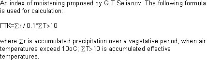
 is the accumulated effective temperatures.