

11 December 2017
Prototype land cover map of Africa: Great start but more accuracy needed
Land cover maps serve a vital purpose in achieving sustainability. As well as tracking deforestation and other forms of habitat and biodiversity loss, they also provide vital information on food security, and data for climate change studies. Accurate land cover maps for Africa are especially crucial, as many vulnerable countries on the continent lack important data on monitoring progress towards the UN Sustainable Development Goals.
The new map, published in September 2017 by the European Space Agency Climate Change Initiative (CCI), was created using images from the Copernicus satellite and is the first of such high resolution for Africa. IIASA researchers conducted a rigorous accuracy assessment of the data using 23,264 validation points from two independent datasets. The final result—65% accurate—was lower than expected, with accuracy especially low in southern countries and in a band from the horn of Africa to Senegal.
“Our work is a call to improve the accuracy of the new CCI map, and it will also provide the researchers and policymakers using it with important information about the uncertainty surrounding data, and therefore how sure they can be of any calculations or decisions based on it,” says Myroslava Lesiv, IIASA researcher and lead author on the report.
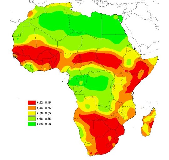
Spatially explicit overall accuracy of the CCI map at 20 m. This is the first land cover map produced at such a high resolution, covering an entire continent for the year 2016. © Lesiv et al., 2017.
“The current accuracy numbers show that there is tremendous room for improvement,” says Steffen Fritz, IIASA Ecosystems Services and Management Program deputy director and an author of the report. “While the resolution is there, the accuracy is not. But that doesn’t mean that this is the final product; it’s the first of its kind and it will advance over the coming years.”
To improve the map, more high-quality data is needed to “train” the algorithm to categorize the images more accurately. To do this, researchers can collect more data on the ground or use visual interpretation of high resolution imagery. The latter method was used by the IIASA Geo-Wiki project for one of the independent verification datasets. After being trained on how to identify different types of land cover in the images, the team were able to categorize 23,264 sample sites with a high level of confidence.
“One of the reasons the CCI map isn’t so good is that some training data came from existing maps rather than new data, which maybe propagated the errors,” says Fritz. “By using the Geo-Wiki interface we were able to train a team to provide a good quality dataset that doesn’t suffer from the same problems. This technique was useful in the assessment of the CCI map and it can also be useful to improve its accuracy by training the algorithm with similar data. The more high quality training data you have, the better the map.”
Reference
Lesiv M, Fritz S, McCallum I, Tsendbazar N, Herold M, Pekel J-F, Buchhorn M, Smets B, et al. (2017). Evaluation of ESA CCI prototype land cover map at 20m. IIASA Working Paper. IIASA, Laxenburg, Austria: WP-17-021
CONTACT DETAILS
Program Director and Principal Research Scholar Strategic Initiatives Program
Principal Research Scholar Novel Data Ecosystems for Sustainability Research Group - Advancing Systems Analysis Program
Senior Research Scholar Novel Data Ecosystems for Sustainability Research Group - Advancing Systems Analysis Program
More information
PUBLICATIONS