

12 September 2016
Cropland Validation: IIASA’s Latest Citizen Science Campaign
According to the Food and Agriculture Organization (FAO), global agricultural productivity must increase by at least 70% by 2050 in order to guarantee food production for future generations. To achieve this goal, more efficient and sustainable production methods need to be adopted that focus on the long term environmental effects of agricultural dynamics.
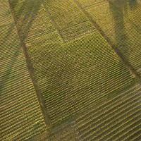
The overall objective of the Cropland Validation Campaign is to classify and validate around 40,000 sample areas as to whether they are cropland or not, which will help IIASA researchers improve their baseline map of cropland extent. This layer will form a critical input to the economic land use model, GLOBIOM, which will be used to examine the environmental impacts of agricultural intensification and expansion in the future.
How can I Join the Campaign?
This is very simple! Go to our Geo-Wiki platform. If you are new to Geo-Wiki, ''Register'' and then login to the Geo-Wiki portal with your email address and password. Click on the ''Enter Application'' button, select the ''SIGMA'' branch from the dropdown box and click on ''Start Validation''.
Join our Cropland Validation Campaign now and help science tackle global problems like future food security! You could win some fabulous prizes as well! The top 30 participants (ranked by a combination of the highest quality and quantity of validations) will receive either co-authorship on a scientific paper, with an impact factor of at least 2.0, or an Amazon gift voucher, ranging from 750 to 50 EUR. The choice is yours!
For more info go to: http://geo-wiki.org/branches/sigma/
The ''Cropland Validation Campaign'' is being launched within the framework of the EC funded SIGMA (Stimulating Innovation for Global Monitoring of Agriculture) project. The SIGMA project develops innovative methods and indicators to monitor and assess progress towards sustainable agriculture. This is based on the integration of in-situ and Earth Observation data in order to facilitate the prediction of the impact of crop production on ecosystems and natural resources in support of GEOGLAM, an initiative of the Group on Earth Observations Global Agricultural Monitoring.Launched by the G20 Agriculture Ministers in June 2011 in Paris, GEOGLAM aims to strengthen global agricultural monitoring by improving the use of remote sensing tools for crop production projections and weather forecasting.

PUBLICATIONS