

Quantifying global land resources
The total land surface area of the Earth is over half a billion square kilometers. Satellite imagery combined with ground-based data and spatial mapping tools are useful for providing the big picture. However, in some areas, not enough data are available or there is disagreement among experts about what the data show.
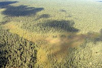
Retrieving reliable detailed data, even from advanced satellite imagery, is a complex task, as IIASA scientists discovered when producing a large-scale boreal forest biomass inventory and map from satellite information covering the vast forest tracts of Siberia.
IIASA has been working for several decades to gather and analyze data with respect to world land resources. For the last 30 years, IIASA and the Food and Agriculture Organization (FAO) have been developing a database of land resources, The Global Agro-ecological Zones (GAEZ) system, which allows the biophysical limitations and production potentials of areas to be evaluated for rational land-use planning purposes.
IIASA and FAO have also has built the Harmonized World Soil Database (HWSD), a GIS-linked global database containing up-to-date information on world soil resources. The HWSD allows soil parameters, for example, organic carbon, pH, water storage capacity, soil depth, etc., to be viewed at high resolution to assess given areas' viability for crop production.
Having achieved a Hybrid Land Cover Map of Russia, IIASA is currently working with international experts from international organizations such as FAO, IFPRI, ILRI and ICRISAT, as well as universities and national experts, to create a global hybrid land cover/land use map at a 1 km resolution. A growing international community of experts is involved in this project, with participants being encouraged to contribute geo-tagged photos, validation points, and existing reference validation data sets in a continuing international collaboration via Geo-Wiki, hosted at IIASA.
The ambitious project seeks to discover the most detailed information possible about land across the globe, including the types of agricultural and tree crops being grown, and whether or not the land is irrigated.
Related IIASA Programs
Land Cover Maps: Models and Databases