

Models, tools, and data


The Trait Ecology and Evolution (Plant) model
Responding to the need among vegetation researchers for a flexible toolbox for investigating the eco-evolutionary dynamics of vegetation, EEP co-developed the Plant model, a comprehensive software package for studying the ecology and evolution of plant communities. More

Statistical analysis for spatial land use data
A prerequisite to the development of realistic models of land use change is the identification of the most important drivers of change. This tool gives an investigator a possibility to summarize the knowledge about interdependent spatial processes in the GIS lattice. Let alone, such a summary can help to draw substantive conclusions about the region under study. More

Reconciling information from alternative sources
Studies of complex systems are non-separable from the analysis of partial and imprecise information received from alternative sources. A system analyst deals with a set of ensemble outcomes which needs to be integrated into one estimate in order to install the ensemble into the modelling chain or provide support for the informed decision making. More
BioGeoChemistry Management Model (BGC-MAN)
Assessing management impacts on the BioGeoChemistry of ecosystems More


Probabilistic approach to address temporal verification of changes in global net carbon emissions under the Kyoto Protocol
This study proposes an approach which permits assessing net emission changes under the Kyoto Protocol, in particular with respect to atmospheric CO2 and CO2 emissions from fossil fuel burning, cement manufacture and gas flaring; whereby emission changes are characterized by uncertainty distributions in terms of verification times (VTs). More

Uncertainty in an Emissions Constrained World: Method Overview and Data Revision
The study by Jonas et al. (2014) “Uncertainty in an Emissions Constrained World” introduces the emissions-temperature-uncertainty (ETU) framework that allows any country to understand its near-term mitigation and adaptation efforts in a globally consistent and long-term context which includes all countries and stipulates global warming to range between 2 and 4 °C. The revised and updated data set supporting the ETU framework is the basis for analyzing greenhouse gas emission targets scaled from global to regional (here EU 27) to national levels (here Austria). More

Stochastic Quasigradient (SQG) methods: Applications
Stochastic Quasi-Gradient (SQG) methods have been developed for solving general optimization problems without exact calculation of objective function and constraints (let alone of their derivatives). SQG methods enable a sequential revision of approximate solutions towards the optimal using newly acquired information on the system, obtained via either direct on-line observations or(and) simulations. More
Framework for Eco-Genetic Modeling
The framework for eco-genetic modeling offers flexible tools for exploring the course and rates of multi-trait life-history evolution in natural populations. More

R Library for Estimating Fisheries-Induced Selection Pressures
The Working Group on Fisheries-Induced Evolution (WGEVO) of the International Council for the Exploration of the Sea (ICES) has developed a general framework for investigating eco-evolutionary changes in fish stocks and their utilities in terms of ecosystem services and for assessing the management implications of fisheries-induced evolution through Evolutionary Impact Assessments (EvoIAs). More
Large Community-Evolution Models (LCEMs)
The complexity and dynamical nature of community interactions make modelling a useful tool for understanding how biodiversity patterns in communities develop over time and how they respond to external perturbations. More

Tools for Assessing Incentive Mechanisms
Ensuring that common goods and open-access resources—everything from clean air and the global climate to the internet and civil security—are equitably and fairly available to everyone requires incentive mechanisms. More

Disease-Eradication Model
Despite modern medical interventions, infectious diseases continue to generate huge socio-economic losses. More

Database of Exploited Fish Stocks
The Working Group on Fisheries-Induced Evolution (WGEVO) of the International Council for the Exploration of the Sea (ICES) has developed a general framework for investigating eco-evolutionary changes in fish stocks and their utilities in terms of ecosystem services and for assessing the management implications of fisheries-induced evolution through Evolutionary Impact Assessments (EvoIAs). More
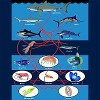
Database of Quantified Food Webs
Biodiversity patterns in natural ecosystems are dynamically sustained by food webs, describing the feeding relations among all ecosystem compartments, including the involved animal and plants. More

Consistent algorithm for linking distributed models under asymmetric information
The linkage algorithms solve the problem of linking models, e.g. sectorial and/or regional, into an inter-sectorial inter-regional integrated model. Linkage enables to avoid “hard linking” of models in a single code, which saves the programming time and enables parallel distributed computations of individual models instead of a large scale integrated model. Models linkage preserves the structure of the original models taking into account critically important details, which are usually missing in aggregate models More

FABLE Scenathon
Scenathons: Interactive Scenario and Development Pathway Planning More

City Oases
Where are the best places for a romantic date? Where can you skate? Where is it cool on a hot summer's day? Find the perfect places to spend the day and share them with the City Oases App! More

Qualitative systems analysis tools to inform strategic planning for policymaking
The current state of the world affairs calls for a revival of systems thinking to improve decision-making. Recognizing that the tightening of socio-economic links heightens the need for holistic responses, that disciplinary and sectorial solutions are of limited effectiveness and efficiency, and that big data is not generating integrative perspectives by itself, highlights the need for policymakers to become thoroughly familiar with the promises and pitfalls of systems analysis. Challenges are systemic, dynamic, and interconnected, and systems analysis, coupled with an improved anticipation, provides a coherent methodology and necessary tools to develop new approaches so urgently required for more coherent and effective policy planning. More

Integrated Risk and Multi-Criteria Decision Analysis
We are developing and applying a range of methods for integrated multi-attribute evaluation under risk, subject to incomplete or imperfect information, and evaluations of decision situations using imprecise utilities, probabilities, and weights, as well as qualitative estimates between these components derived from sets of weight, utility and probability measures. To avoid some mathematical aggregation problems when handling set membership functions and similar, we use higher-order distributions for better discrimination between the possible outcomes. More

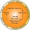
Behavioral economics methods for evaluation of cognitive and behavioral patterns of individual decision-making
Contested policy issues require understanding of behavioral factors of various stakeholders who are participating in decision-making processes and are affected by policy interventions. Behavioral goals govern or ‘frame’ what people attend to, what knowledge and attitudes become cognitively most accessible, how people evaluate various aspects of the situation, and what alternatives are being considered. More
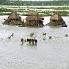
Flood Resilience Measurement for Communities
The FRMC was created by the Zurich Flood Resilience Alliance in 2013 and is an innovation in community flood resilience theory and practice. It allows users to generate evidence about the ways in which a given area or community is already resilient to floods, as well as providing a guide to further develop this resilience. More
Postharvest Storage App
The Postharvest Storage app collects information on the types of storage mechanims used by farmers for storing their harvests More

GROW Observatory App
The GROW Observatory app is a service stemming from the GROW Observatory project, a European Citizen Science project on growing food, soil moisture sensing and land monitoring that ran from 2016-2019. More

Picture Pile
Picture Pile is an online and mobile application for rapid image classification, which can be used to collect data for the development or validation of remotely sensed map products or to provide new inputs to machine learning algorithms. More
NaturaAlert
Natura Alert is a mobile and web application to report threats in protected areas, in particular, in Important Bird and Biodiversity Areas (IBAs) globally and in Natura 2000 sites in the EU More

FotoQuest Go
FotoQuest Go is a mobile app for the collection of in situ land cover and land use data by citizens, including geo-tagged photographs that document the landscape More

AgroTutor
AgroTutor provides highly specific and timely agricultural recommendations to farmers across Mexico and complements the work of local extension agents. Although most of the benchmarking information provided in the app is specific to Mexico, some of the functionalities can be used anywhere in the world. Give it a try! More


FloodCitiSense
The FloodCitiSense mobile and web applications were developed as part of the FloodCitiSense project, which is an early warning service for urban pluvial floods. More

Wicked policy problems and participatory qualitative system modeling
The policy planners have a dual challenge – at the same time they have to solve usual for them problems which existed for a long time and they also have to deal with everyday emergency problems, which are changing according to the conditions of the environment. To solve this challenge, they frequently use existing solutions as well as past traditions. Such approach filters new observations and solution ideas. Participatory qualitative systems analysis is one of the several techniques to solve this dual challenge in policy planning. More

Map Accuracy Tools
Map Accuracy Tools is an online website for calculating accuracy metrics for land cover products and for exploring thematic map accuracy. More

PUBLICATIONS